
I flew to these 2 places and was emotionally moved by the images. I went up and inside the Statue of Liberty many years ago but couldn't go all the way up because the crown was being reconstructed. The view was incredible. I have always wondered about the other image and what it would be like to really see Christ the Redeemer in Brazil. I find it so fascinating and although I have never been there, I consider this to be one of my favorite places. In Google Earth I also saw images of my home, the schools my children attend and my church, St. John the Evangelist.


This is UMASS with 5 points of on campus interest.
I turned on the different layers of Google Earth and found a few different ways to view the location. The most intriguing layer was 3D. When this layer is clicked or checked all the buildings within your location come to life. They are all visible in a third dimensional format. I checked the 3D buildings layer in Google Earth and flew to Boston. If you are familiar with Boston you should be able to point out the Prudential Building. The images below show the same image with the 3D layer checked on and off.


This is a flight tracking image:
Flight Details
Altitude: 36,000 ft Radio Call: UNITED
Speed: 420 kts Aircraft: B744/Q Boeing 747-400
VFR Information
This flight is currently flying under VFR "flight-following" rules and, as such, departure and destination information is not available.
Departure Information
Departed: SFO SAN FRANCISCO INTL
Departure Time: 11/16/2009 11:36 AM PST (1936Z)
Air Traffic Summary Air Traffic Map Airport Info
Destination Information
Destination: RJAA NEW TOKYO INTL
ETA: 06:08 AM GMT (0608Z) (In 5h 42m)

Here is a vessel tracking image of cuise ships sailing within the Carribean.
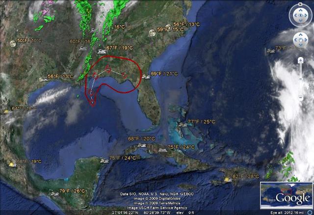
Here is weather tracking image around the same area of the sailing cruise ships within the Carribean.
No comments:
Post a Comment